Come rain or shine
-
- from Shaastra :: vol 04 issue 05 :: Jun 2025
Despite the inclement hiccups, weather nowcasting has taken off.
Bipasha Paul Shukla was a relative newbie at the Space Applications Centre (SAC), a research centre of the Indian Space Research Organisation (ISRO), in Ahmedabad in 2008 when she was tasked with a novel project. She had to use data from the geostationary meteorological satellite Kalpana-1 to predict weather images that the satellite would produce over the following few hours. For Shukla, an applied mathematician, it was the first step into the field of nowcasting weather. Meteorological nowcasting, or the science of predicting what the weather over a specific location would likely be in the next few hours, is one of the most challenging aspects of weather forecasting.
A few years after Shukla started on the project, SAC began developing models for nowcasting weather for rocket launches at the Satish Dhawan Space Centre in Sriharikota. "In addition to satellite data, we began adding more and more meteorological and climatological parameters into the system," recalls Shukla, now head of the recently formed Environmental Sciences Division at the SAC. As the models got richer data inputs, the nowcasting outcomes got more refined.
Since nowcasting is relatively new, there are significant gaps. Poor data resolution is a problem; increasing radar and satellite data resolution may help.
Shukla, who was then working with the Atmospheric Sciences Division, went on to lead the development of two satellite-based nowcasting models. The Nowcasting of Extreme Orographic Rain (NETRA) algorithm helps identify vulnerable spots where heavy rainfall or a cloudburst can potentially happen. The Hydro-Estimator (HE) Nowcaster, which was developed in 2024, is a precipitation nowcasting model for all of India using satellite-based geospatial techniques. It gives forecasts three hours in advance, with an update every 30 minutes, and predicts how and where the rain systems will move over time. These satellite-based nowcasting algorithms are available as web-GIS-based tools, hosted by mosdac.gov.in, and are freely available for users.
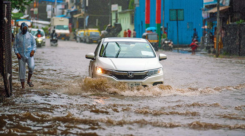
The need for accurate nowcasts and short-range forecasts (predicting an extreme event three to four days ahead) has increased with rising urbanisation. With higher population densities in ecologically fragile geographies and altered wind and heat patterns, the devastation caused by extreme weather events leaves a larger footprint. Recent examples of single-day flooding in metropolises such as Mumbai, Chennai and Delhi, leading to a loss of lives, are cases in point. Around 65% of the total number of large extreme rainfall events between 1951 and 2015 occurred after 2000, according to a paper published in Nature (go.nature.com/4dBVGBm). "Some of the major floods in recent decades over India are attributed to these large events," it says. While nowcasts are meant for all kinds of weather events — rain, fog, hail, heat wave, lightning and thunder — much of the focus in India is on nowcasting heat and rain.
HITS AND MISSES
Large-scale phenomena such as the monsoons are picked up by satellite imagery, radar recordings, and various other instruments and tracked for long periods. Nowcasting involves forecasts over a small area for a small period. Dust devils, for instance, develop and dissipate within half an hour and can cause substantial damage. "Often, these systems are difficult to detect on existing models," says Mrutyunjay Mohapatra, Director General of Meteorology, India Meteorological Department (IMD). When the event involves multiple phenomena, the difficulty level for prediction rises. On May 2, 2025, Delhi received 77 mm of rainfall in six hours, its third-highest single-day rainfall for May. The rain was preceded by a dust storm and accompanied by thunder, lightning and squalls with speeds of 80 kmph. The Met Department gave regular nowcasts for the approaching drama. Still, it failed to predict the volume of precipitation, although it had the inputs: the building of low pressure over the Capital, the development of a western disturbance and the incursion of moisture from the Bay of Bengal. It only issued an orange alert.
Since nowcasting is a relatively new area of research, there are significant gaps. In some cases, poor data resolution is a problem. Increasing radar and satellite data resolution could help to some extent. Under Mission Mausam, the Ministry of Earth Science's endeavour to make India "weather-ready and climate-smart", plans are afoot to increase the number of Doppler radars from the present 40 to 100 and launch more advanced weather observation satellite payloads and commission other weather surveillance systems. It also seeks to harness data-driven forecasting with artificial intelligence (AI) and machine learning (ML).
"Predicting rainfall accurately on any time or temporal scale is difficult, especially in the tropics," says Raghu Murtugudde, Emeritus Professor of Climate Sciences at the University of Maryland, U.S. He has a favourite "kettle of popcorn" analogy: land, like the kettle, heats up uniformly, while rain is like popcorn: you can never accurately predict where it will fall.
In some cases, the science of forecasting itself has to be developed. For instance, according to Shukla, there are no direct equations to forecast a cloudburst. The best available is technology to predict the likelihood of it happening over a particular area. A cloudburst is an event of sudden and intense rainfall over a small area with precipitation of over 100 mm/10 min (regular heavy rainfall is 5-30 mm/hour). Cloudbursts, which usually occur in the hilly areas, are more common in the early monsoon over the Western Himalayas. They often lead to flash floods and landslides, causing large-scale devastation. Nowcasting technology for hail occurrence is not very advanced either.
The paucity of local data is a limiting factor. One part of a city may experience very heavy rainfall, while another may be dry. This happened in 2024 in New Delhi, where extremely heavy rain in areas such as Karol Bagh caused urban floods and the death of students trapped in a basement. Several other parts of the city saw only a smattering of rain that day. Fine-grained forecasting requires long-term, localised data, which are not available. Running models to nowcast over such specific geographies requires high investments and running time.
The need for accurate nowcasts and short-range forecasts has increased with rising urbanisation. The devastation caused by extreme weather events leaves a larger footprint.
Even when equipped with big data, the biggest challenge nowcasts face is the ability to process them at speed into usable results. Too many approximations affect the quality of the forecast. Traditional models have a long "spin-up time"; often, an event may already be occurring by the time the result is ready. "Data-driven models that use AI may produce better outcomes," says Murtugudde. In any case, data provide the backbone. Mohapatra, however, underlines the progress in the field. "Despite these gap areas, nowcasting technology has advanced significantly over the last decade and continues to improve," he notes.
Among the advances are the use of neural networks and hybrid models. Nowcasts use the latest "bagging and boosting" technologies, where multiple models train on the data to create ensemble models. Nowcasters also use deep networks with multiple layers of data exchanging information among themselves.
The May 2025 launch of the Bharat Forecasting System, a numerical-based indigenous model for short-range forecasts, is expected to be a shot in the arm for weather preparedness in India. The system, developed at the Indian Institute of Tropical Meteorology (IITM), Pune, uses a novel triangular-cubic-octahedral grid that enhances resolution over the tropics to 6 km, while over the polar regions, the resolution is coarser, at around 8 km. Such fine resolution can provide panchayat-level forecasts, a vast improvement from the earlier model with a resolution of 12 km. "This model provides faster and more accurate outputs at low computational power and higher resolution. It is the first model in the world with such fine resolution," says M. Ravichandran, Secretary, Ministry of Earth Sciences. He adds that given the chaotic manner in which weather systems change, both temporally and spatially in the tropics, a finer resolution is required for these regions.
The model has been running on an experimental basis since 2022, but the existing computing systems could not generate outputs at speed; they had a running time of around 13 hours for a ten-day forecast, says IITM head Suryachandra Rao. The processing speed has been enhanced with the induction of high-performance computing last year. The forecasting skill for the core monsoon region has improved by 64%, and extreme rainfall prediction events have improved by 20%. For the best nowcasting, however, the resolution needs to improve to the street level with a 1-km resolution.
NEW INSIGHTS
As scientists understand weather more deeply, they are discovering that local and regional phenomena could have planetary signatures at great distances from the actual event. Monitoring their development could help create more accurate forecasts. For instance, stationary Rossby wave rays over the Atlantic Ocean are connected to significant rainfall events in India during the summer monsoon season. "These events could be considered as precursors for a local extreme rainfall event," notes Akshaya Nikumbh, Assistant Professor and head of the Atmospheric Convection and Dynamics Group, Indian Institute of Technology (IIT) Bombay. Her research has shown that these waves influence large rain events not just in North India but also over central India (bit.ly/Atlantic-role). As such events develop many days ahead, monitoring them might give the necessary warning of possible events in India and provide better short-range forecasts.
While nowcasting a very heavy rain event is one aspect of being weather-ready, a complementary facet is the inundation forecast. "The urban landscape differs greatly from a riparian landscape with its constantly changing built-up structures and drainage patterns. Each city requires a bespoke model for flood forecasting," according to Manabendra Saharia, Associate Professor at the HydroSense Lab at IIT Delhi.
He is working on developing an urban flood prediction model for Guwahati. Only a few cities, such as Chennai, have such a model. A combination of robust nowcasting and flood prediction models can lead to "very actionable results" in weather-readiness, Saharia believes. While nowcasts are only for a few hours' forecast, very short-range accurate forecasts, with a 12-to-24-hour warning system, can help administrations prepare better.
As scientists understand weather more deeply, they find that local and regional phenomena could have planetary signatures at great distances from the actual event.
His lab, in association with the IMD, recently developed the India Precipitation Ensemble Dataset, which leverages the network of 3,966 precipitation gauges across the country with daily data of 30 years. Among the various uses of the product is its potential for predicting extreme rain events. Similarly, the Composite Landslide Infrastructure Vulnerability Index is a scientific tool for prioritising risk reduction measures. The index brings together the inbuilt vulnerability of an area to landslides and the vulnerability of human-built infrastructure — roads, rail and buildings. Kerala's Kottayam district, with a rating of 0.67, has the highest composite landslide vulnerability in India. This index, when integrated with early warning and real-time monitoring, could enhance disaster preparedness. Landslides and floods are technically not meteorological events, but their correlation with the weather event is strong (Tech tools that help map landslides).
Newer understandings of related phenomena, the creation of comprehensive datasets and forecasting algorithms, and, most important, users' demand for accurate nowcasts are propelling the science of nowcasting. Mohapatra points out that he recently met a delegation of auto-rickshaw drivers who wanted the IMD to issue weather nowcasts tailored for them. An inter-State bus terminus, too, has asked for nowcasts, he says. In these times of adapting to a changing climate, nowcasting is an important step towards being weather-ready.
See also:
Monsoon musings
Let's take a monsoon rain check
Flashback, fast forward
It's raining solutions


Crossroads of science
The year 2025 has been a momentous one for science and technology. The impact of this will be felt over the next decade.

Brave new world
How the power of geographical connection was used to reshape the world.

This scavenger has come back from the dead
After the ban on the veterinary use of a drug responsible for killing vultures, steps taken to save the scavengers are showing results.
Have a
story idea?
Tell us.
Do you have a recent research paper or an idea for a science/technology-themed article that you'd like to tell us about?
GET IN TOUCH